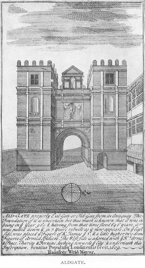
Aldgate
Aldgate (/ˈɔːlɡeɪt/) was a gate in the former defensive wall around the City of London.
For other uses, see Aldgate (disambiguation).Ward of Aldgate
2.3 mi (3.7 km) WSW
United Kingdom
The gate gave its name to Aldgate High Street, the first stretch of the A11 road, that takes that name as it passes through the ancient, extramural Portsoken Ward of the City of London.
There is an ancient Aldgate Ward inside the line of the former gate and wall, and a similarly ancient Portsoken Ward that lies just outside of it. However the use of the Aldgate and Portsoken Wards as everyday place names is very limited.
Consequently, the use of Aldgate as a place name is informal, and typically applies to the Portsoken Ward, especially the central area around Aldgate High Street.
Aldgate High Street is 2.3 miles (3.7 km) east of Charing Cross.
$_$_$DEEZ_NUTS#0__titleDEEZ_NUTS$_$_$
$_$_$DEEZ_NUTS#0__subtitleDEEZ_NUTS$_$_$
Etymology[edit]
The etymology of the name "Aldgate" is uncertain. It is first recorded in 1052 as Æst geat ("east gate") but had become Alegate by 1108.[1] Writing in the 16th century, John Stow derived the name from "Old Gate" (Aeld Gate). However, Henry Harben, writing in 1918, contended that this was wrong and that documents show that the "d" is missing in documents written before 1486–87. Alternative meanings include "Ale Gate" in connection with a putative ale-house or "All Gate" meaning the gate was free to all. Other possibilities canvassed by Harben include reference to a Saxon named "Ealh," or reference to foreigners ("el") or oil ("ele") or "awl". Gillian Bebbington, writing in 1972, suggests Alegate, Aelgate ("public gate") or Aeldgate ("Old Gate") as equally viable alternatives, while Weinreb and Hibbert, writing in 1983, revert to Stow's theory that the name means "Old Gate".[2][3][4]
$_$_$DEEZ_NUTS#1__titleDEEZ_NUTS$_$_$
$_$_$DEEZ_NUTS#1__descriptionDEEZ_NUTS$_$_$
Aldgate locality[edit]
Geography[edit]
The originally Roman A11 Road, once known as the Great Essex Road, is known as Aldgate High Street as it passes through the Portsoken Ward, and the use of Aldgate as a place name typically applies to this extramural area around Aldgate High Street. The High Street is around 290 metres (950 feet) long. Due to the road geography, and its historic interest, the Aldgate Pump, a few metres inside the position of the former gate is also usually included.
Immediately east of Aldgate High Street the road becomes known as Whitechapel High Street as it enters the Whitechapel area of the London Borough of Tower Hamlets. The stretch of Whitechapel High Street extending as far as Gardiners Corner, and including Aldgate East tube station is also occasionally referred to as part of Aldgate.
History[edit]
The church of St Botolph's Aldgate stands just outside the position of the former gate, and was in place by 1115, though some traditions suggest an earlier origin.[11]
In about 1420 the Whitechapel Bell Foundry was founded in Aldgate, but it later moved to nearby Whitechapel. The foundry continued to supply bells to churches in the city, including the rebuilt church of St Botolph without Aldgate in 1744.[12]
During the late 16th-century, an immigrant from Antwerp named Jacob Jansen (d. 1593) established a pottery producing English Delftware at Aldgate.[13]
A Jewish community developed in the area after Oliver Cromwell invited the Jews to return to England. They established London's oldest synagogue at Bevis Marks in 1698,[14]
In 1773 Poems on Various Subjects, Religious and Moral by Phillis Wheatley, the first book by an African American was published in Aldgate after her owners could not find a publisher in Boston, Massachusetts.[15]
Daniel Mendoza was born in 1764 to a Jewish family in Aldgate. He was author of The Art of Boxing and became an English boxing champion from 1792 to 1795.[16]
Transport[edit]
The nearest London Underground station is Aldgate on the Circle and Metropolitan lines; nearby Aldgate East is served today by the District and Hammersmith & City lines. Nearby mainline railway stations are located at Liverpool Street and Fenchurch Street, and Tower Gateway is the closest Docklands Light Railway station.
$_$_$DEEZ_NUTS#2__titleDEEZ_NUTS$_$_$
$_$_$DEEZ_NUTS#2__subtextDEEZ_NUTS$_$_$