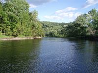
Connecticut River
The Connecticut River is the longest river in the New England region of the United States, flowing roughly southward for 406 miles (653 km) through four states. It rises 300 yards (270 m) south of the U.S. border with Quebec, Canada, and discharges at Long Island Sound.[4] Its watershed encompasses 11,260 square miles (29,200 km2), covering parts of five U.S. states and one Canadian province, via 148 tributaries, 38 of which are major rivers.[5] It produces 70% of Long Island Sound's fresh water,[5] discharging at 18,400 cubic feet (520 m3) per second.[6]
Connecticut River
United States
2,660 ft (810 m)
410 mi (660 km)
11,260 sq mi (29,200 km2)
18,400 cu ft/s (520 m3/s)
968 cu ft/s (27.4 m3/s)
282,000 cu ft/s (8,000 m3/s)
6,600 cu ft/s (190 m3/s)
Connecticut River Estuary and Tidal River Wetlands Complex
October 14, 1994
710[3]
The Connecticut River Valley is home to some of the northeastern United States' most productive farmland, as well as the Hartford–Springfield Knowledge Corridor, a metropolitan region of approximately two million people surrounding Springfield, Massachusetts, and Hartford, Connecticut.[7]
Economy[edit]
Boating[edit]
The mouth of the river up to Essex is thought to be one of the busiest stretches of waterway in Connecticut. Some local police departments and the state Environmental Conservation Police patrol the area a few times a week. Some towns keep boats available if needed.[75] In Massachusetts, the most active stretch of the Connecticut River is centered on the Oxbow, 14 miles (23 km) north of Springfield in the college town of Northampton.[76]
Camping is available along much of the river, for non-motorized boats, via the Connecticut River Paddlers' Trail. The Paddlers' Trail currently includes campsites on over 300 miles (480 km) of the river.[77]


