Katana VentraIP

Galveston Bay

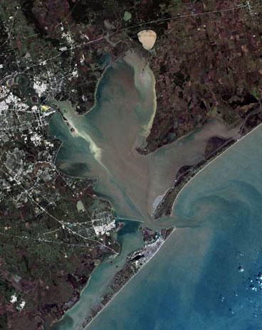
Galveston Bay (/ˈɡælvɪstən/ GAL-vis-tən) is a bay in the western Gulf of Mexico along the upper coast of Texas. It is the seventh-largest estuary in the United States,[2] and the largest of seven major estuaries along the Texas Gulf Coast. It is connected to the Gulf of Mexico and is surrounded by sub-tropical marshes and prairies on the mainland.[3] The water in the bay is a complex mixture of sea water and fresh water, which supports a wide variety of marine life. With a maximum depth of about 10 feet (3 m) and an average depth of only 6 feet (2 m), it is unusually shallow for its size.

Galveston Bay

30 miles (48 km)

17 miles (27 km)

345,280 acres (139,730 ha)[1]

6 feet (1.8 m)

10 feet (3.0 m)

The bay has played a significant role in the history of Texas. Galveston Island is home to the city of Galveston, the earliest major settlement in southeast Texas and the state's largest city toward the end of the nineteenth century.[4] While a devastating hurricane in 1900 hastened Galveston's decline, the subsequent rise of Houston as a major trade center, facilitated by the dredging of the Houston Ship Channel across the western half of the bay, ensured the bay's continued economic importance.[5]


Today, Galveston Bay is encompassed by Greater Houston, the fifth-largest metropolitan area in the United States.[6] The Port of Houston, which has facilities spread across the northwestern section of the bay, is the second-busiest port in the nation by overall tonnage.[7] Other major ports utilizing the bay include the Port of Texas City and the Port of Galveston. With its diverse marine life, Galveston Bay also produces more seafood than any estuary in the United States except the Chesapeake.[8]

List of bays of the Houston area

Antrobus, Sally (2005). Galveston Bay. . ISBN 1-58544-461-8.

Texas A&M University Press

Cairns, William J.; Rogers, Patrick M. (1990). . Taylor & Francis, Inc. ISBN 978-0-85334-974-7.

Onshore impacts of offshore oil

Eubanks, Ted; Behrstock, Robert A.; Weeks, Ron J. (2006). . Texas A&M University Press. ISBN 1-58544-510-X.

Birdlife of Houston, Galveston, and the Upper Texas Coast

Henson, Margaret Swett (1993). . Galveston Bay Estuary Program. Archived from the original on December 15, 2009.

The history of Galveston Bay resource utilization

Melosi, Martin V.; Pratt, Joseph A. (2007). . University of Pittsburgh Press. ISBN 978-0-8229-4335-8.

Energy metropolis: an environmental history of Houston and the Gulf Coast

Newcomb, William Wilmon (1961). . Austin, TX: University of Texas Press. ISBN 0-292-78425-2.

The Indians of Texas: From Prehistoric to Modern Times

Ramos, Mary G.; Reavis, Dick J. (2004). . Random House. ISBN 0-676-90502-1.

Texas

National Ocean Service

Ellender to Galveston Bay, Louisiana—Texas: Intracoastal Waterway Nautical Chart

National Ocean Service

Galveston Bay to Cedar Lakes, Texas: Intracoastal Waterway Nautical Chart

See an 1853 map , hosted by the Portal to Texas History.

Preliminary chart of San Luis Pass, Texas / from a trigonometrical survey under the direction of A.D. Bache ; triangulation by James S. Williams ; topography by J.M. Wampler ; hydrography by the party under the command of H.S. Stellwagen ; engg. by E. Yeager & J.J. Knight ; redd. drng. by E. Freyhold.

Galveston Island State Park

Galveston Bay Status and Trends

U.S. Geological Survey Geographic Names Information System: Galveston Bay