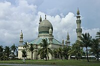
Kuala Belait
Kuala Belait (Malay: Pekan Kuala Belait; Jawi: کوالا بلايت; abbrev: KB) is the administrative town of Belait District, Brunei.[3][4] The population of the town proper was 4,259 in 2016.[2] Kuala Belait is officially a municipal area (kawasan bandaran),[5] as well as a village under the mukim of the same name.[6] The town is located 85 kilometres (53 mi) west of the country's capital Bandar Seri Begawan,[4] and 20 kilometres (12 mi) west of Seria, the district's other town.[7] It is also in the westernmost part of country, near the mouth of the Belait River.[8]
For the mukim subdivision, see Mukim Kuala Belait.
Kuala Belait
Demography[edit]
Kampong Kuala Balai has historically served as the Belait population's hub. However, the population has scattered over the past 50 years, and now, Belait tribe members may be found in and around the town.[42] By 1938, Kuala Belait's population had increased to 5,000, and the BMPC was the city's major employer, with 1,185 out of 2,265 workers under its payroll.[43] 1,193 people were counted in Kuala Belait at the time of the 1931 census. It was reportedly 12,000 in 1948, due to the development around the district's oilfield.[44] The town has a sizable Chinese population,[45] and most Europeans are concentrated in Kuala Belait and Seria.[46]
Transportation[edit]
Road[edit]
Most of the roads within the municipality are surfaced. There are buses taking passengers to Miri from Kuala Belait.[4] The Kuala Belait Highway from the Malaysian border west of Sungai Tujuh, Kuala Belait links up with multiple other highways leading to Bandar Seri Begawan and Muara Town.[48]


