Katana VentraIP

Los Angeles Street

Los Angeles Street, originally known as Calle de los Negros (Spanish for "Street of the Black [People]") is a major thoroughfare in Downtown Los Angeles, California, dating back to the origins of the city as the Pueblo de Los Ángeles.

Location[edit]

The principal length of the street proceeds north from 23rd Street, past Interstate 10, through the Fashion District, past the western edge of Little Tokyo, past the Caltrans District Headquarters, the former Los Angeles Police Department Headquarters at Parker Center and the Los Angeles Mall (which contains City Hall East).


Los Angeles Street ends at Alameda Street, north of the US 101 near Olvera Street and Union Station.


In South Los Angeles there are two other portions of Los Angeles Street, one running from Slauson Avenue to 59th Place and another from 122nd Street to 124th Street near Willowbrook.

History[edit]

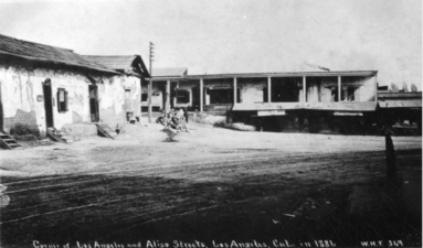
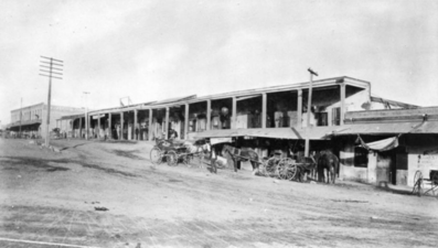
The block of Los Angeles Street that runs by the Old Plaza was originally known as "Calle de los Negros" or "Alley of the Black People". On late 19th century maps it is also marked with a contemporary English translation of that phrase, Nigger Alley.[1] The Chinese massacre of 1871 took place on Los Angeles Street when it was still known as Calle de los Negros. The printing house for the city's first newspaper, Star of Los Angeles, was located on Los Angeles Street, which was known at the time as Calle Zanja Madre (Mother Ditch street).[2]


Los Angeles Street was the easternmost street in the city's central business district during the 1880s and 1890s. Around Los Angeles and 3rd was the wholesale district, which over time moved further and further southeast into what is now the Fashion District and beyond.

Santee Education Complex

Old Chinatown stretched from Sanchez Street across Los Angeles Street to what is now Union Station. c.1885.

Old Chinatown stretched from Sanchez Street across Los Angeles Street to what is now Union Station. c.1885.

Lugo Adobe lining the eastern edge of Los Angeles Plaza. The street in front of the adobe was part of Los Angeles St. starting in the 1880s.

Lugo Adobe lining the eastern edge of Los Angeles Plaza. The street in front of the adobe was part of Los Angeles St. starting in the 1880s.

Chinese American Museum in the Garnier Building

Chinese American Museum in the Garnier Building

1882 view, looking north from Broad Place along Calle de los Negros to the Ignacio Del Valle adobe in the far background. At left, with the peeling paint, is the Coronel Adobe (SE corner of Arcadia). A few years later, both adobes would be demolished and Los Angeles St. would be extended northward to (and past) the Plaza.

1882 view, looking north from Broad Place along Calle de los Negros to the Ignacio Del Valle adobe in the far background. At left, with the peeling paint, is the Coronel Adobe (SE corner of Arcadia). A few years later, both adobes would be demolished and Los Angeles St. would be extended northward to (and past) the Plaza.

Looking east on Arcadia towards houses lining the east side of Broad Place. Aliso Street runs form their right side towards the background. Calle de los Negros runs to the left in front of them. The Coronel Adobe is at left.

Looking east on Arcadia towards houses lining the east side of Broad Place. Aliso Street runs form their right side towards the background. Calle de los Negros runs to the left in front of them. The Coronel Adobe is at left.

Broad Place at north end of Los Angeles Street c.1870s. At back, Coronel Adobe (l), Calle de los Negros (r)

Broad Place at north end of Los Angeles Street c.1870s. At back, Coronel Adobe (l), Calle de los Negros (r)

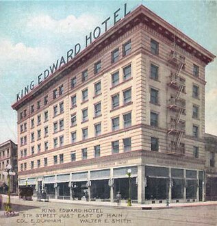
King Edward Hotel (built 1906, NW corner of 5th St.)

King Edward Hotel (built 1906, NW corner of 5th St.)

Baltimore Hotel (built 1910, SW corner of 5th St.)

Baltimore Hotel (built 1910, SW corner of 5th St.)

Corner of 5th St.


Corner of 9th St.

"Calle de los Negros", KCET (Los Angeles Public Television)