Lunar Laser Ranging experiments
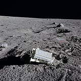
Lunar Laser Ranging (LLR) is the practice of measuring the distance between the surfaces of the Earth and the Moon using laser ranging. The distance can be calculated from the round-trip time of laser light pulses travelling at the speed of light, which are reflected back to Earth by the Moon's surface or by one of several retroreflectors installed on the Moon. Three were placed by the United States' Apollo program (11, 14, and 15), two by the Soviet Lunokhod 1 and 2 missions,[1] and one by India's Chandrayaan-3 mission.[2][3]
Although it is possible to reflect light or radio waves directly from the Moon's surface (a process known as EME), a much more precise range measurement can be made using retroreflectors, since because of their small size, the temporal spread in the reflected signal is much smaller[4] and because the return will be more evenly reflected with less diffusion.
Laser ranging measurements can also be made with retroreflectors installed on Moon-orbiting satellites such as the LRO.[5][6]
The Lunar Laser Ranging data is collected in order to extract numerical values for a number of parameters. Analyzing the range data involves dynamics, terrestrial geophysics, and lunar geophysics. The modeling problem involves two aspects: an accurate computation of the lunar orbit and lunar orientation, and an accurate model for the time of flight from an observing station to a retroreflector and back to the station. Modern Lunar Laser Ranging data can be fit with a 1 cm weighted rms residual.
The range model includes[36][37]
For the terrestrial model, the IERS Conventions (2010) is a source of detailed information.[38]


