Saffron Walden
Saffron Walden is a market town in the Uttlesford district of Essex, England, 12 miles (19 km) north of Bishop's Stortford, 15 miles (24 km) south of Cambridge and 43 miles (69 km) north of London. It retains a rural appearance and some buildings of the medieval period. The population was 15,504 at the 2011 census and 16,613 in the 2021 census.[2]
Not to be confused with Sutton Waldron.Saffron Walden
The 12th-century Walden Castle, built or expanded by Geoffrey de Mandeville, the first Earl of Essex, is in ruins. After the medieval period, the castle fell into disuse and much of the flint was taken and used in the construction of local houses and the wall surrounding the Audley End estate. All that remains is the ruined basement.
Near the castle is a turf maze, a series of circular excavations cut into the turf of the common. It is the largest example of this style of maze in England, the main part being about 100 feet (30 m) in diameter. The earliest record of it dates from 1699, although its origin may be earlier. It has been extensively restored several times, most recently in 1979.[19][20]
The oldest inhabited building in the town is believed to be the former maltings at 1 Myddleton Place. The 15th-century building with a courtyard garden was used by the Youth Hostel Association from 1947 to 2010.[21] It is now used for functions.[22] Pevsner described it as: "without doubt, the best medieval house of Saffron Walden".[23] Other notable early buildings are in Bridge Street, Castle Street and the side streets off the High Street. The High Street contains some late-Georgian and Victorian buildings.[23]
Bridge End Gardens, seven interlinked gardens – including a maze, rose garden and walled garden – were originally laid out by the Gibson family in about 1840. They have been restored with help from the Heritage Lottery Fund and volunteers.[24][25]
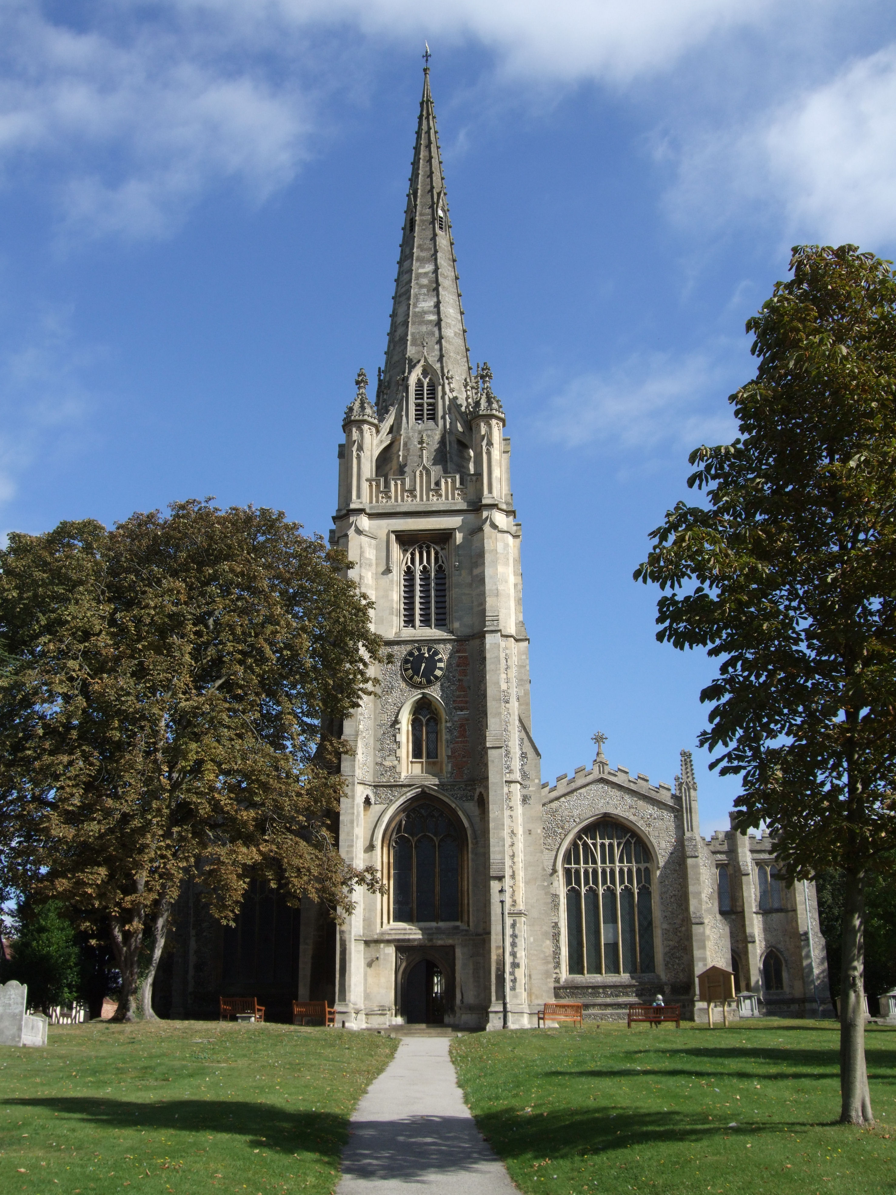
St Mary the Virgin, Saffron Walden (Church of England) is the largest parish church in Essex.[26] The church dates mainly from the end of the 15th century, when an old smaller church was extensively rebuilt by the master mason John Wastell, who was building King's College Chapel in the nearby city of Cambridge. In 1769 it was damaged by lightning and the repairs, carried out in the 1790s, removed many medieval features. The spire was added in 1832 to replace an older lantern tower. The church is 183 feet (56 m) long and the spire, 193 feet (59 m) high, is the tallest in Essex.
The town's Catholic church, Our Lady of Compassion, is on Castle Street. Created in 1906 from a 16th-century barn, it was restored in 2004–5.[27]
With a long history of non-conformism, Saffron Walden has:
[28]
Saffron Walden falls in to three local government administrative areas, including Uttlesford District Council and Essex County Council.
The town itself is administered by Saffron Walden Town Council which has 18 members.[29] The majority party is Residents for Uttlesford ('R4U'), who are a local political party formed by residents. As of 2023 the mayor is Heather Asker of Residents for Uttlesford.
The town is divided into four parish wards: Audley, named after Audley End House - representing the western area of Saffron Walden including Audley End; Castle - taking its name from Saffron Walden Castle; Shire (formerly Plantation) - representing the southern area of the town; and Little Walden - representing the small village of the same name and a large rural area to the north of the town.
Nationally, the town is part of the much larger Saffron Walden Parliamentary constituency. The MP is Conservative, Kemi Badenoch who is Secretary of State for International Trade.
Notable former MPs include:
It has been considered a safe seat for the Conservative Party since 1922.
Demography[edit]
According to the Office for National Statistics, at the time of the United Kingdom Census 2001, Saffron Walden had a population of 14,313. The 2001 population density was 10,900 inhabitants per square mile (4,209/km2), with a 100 to 94.5 female-to-male ratio.[30] Of those over 16 years old, 45.0 per cent were married, 27.4 per cent were single (never married), and 8.2 per cent divorced.[31] The parish's 6,013 households included 38.5 per cent married couples living together, 31.5 per cent one-person households, 8.4 per cent co-habiting couples, and 7.9 per cent single parents with children.[32] Of those aged 16–74, 22.3 per cent had no academic qualifications, close to the average for Uttlesford (22.0 per cent) and below that for the whole of England (28.9 per cent).[33][34]
In the 2001 UK census, 73.0 per cent of Saffron Walden residents declared themselves Christian, 0.6 per cent Muslim, 0.4 per cent Buddhist, 0.2 per cent Jewish, and 0.1 per cent Hindu. The census recorded 17.6 per cent as having no religion, 0.4 per cent with an alternative religion, and 7.8 per cent not stating their religion.[35]
Transport[edit]
Railway[edit]
The nearest station to Saffron Walden is Audley End, which is located 2 miles (3 km) outside the town in the village of Wendens Ambo; regular bus services link it to the town centre.
The station is sited on the West Anglia Main Line between Cambridge and London Liverpool Street. Greater Anglia operates an off-peak service of two trains an hour in each direction, with additional services during peak times; the journey time to London is approximately 55 minutes and approximately 20 minutes to Cambridge.[41] All southbound trains also stop at Tottenham Hale, where there is a London Underground Victoria line station and onward rail connections to Stratford station in east London.
An hourly CrossCountry service between Stansted Airport and Birmingham New Street, via Peterborough and Leicester, also stops at Audley End.[42]
Saffron Walden railway station served the town between 1865 and 1964.[43]
Buses[edit]
Regular bus services connect the town with Cambridge, Bishop's Stortford, Haverhill and Stansted Airport. Operators include Stephensons of Essex and Stagecoach East.[44]
Roads[edit]
Saffron Walden is accessed from junction 8 of the M11 when travelling northboundfrom London (a distance of about 15 miles (24 km)) and from junction 10 when travelling south from Cambridge (8 miles (13 km)).
During the coronavirus pandemic, Essex Highways narrowed some roads in the town centre to make social distancing easier for pedestrians and they reduced some speed limits to 20 miles per hour (32 km/h) as part of their Safer, Greener, Healthier scheme.[45]
Air[edit]
Stansted Airport is located 15 miles (24 km) from the town, while Luton Airport is 43 miles (69 km) away.
Audley End Airfield, a private grass runway, is located about 1 mile (2 km) outside of the town.
Saffron Walden is twinned with: