
Terra (satellite)
Terra (EOS AM-1) is a multi-national scientific research satellite operated by NASA in a Sun-synchronous orbit around the Earth. It takes simultaneous measurements of Earth's atmosphere, land, and water to understand how Earth is changing and to identify the consequences for life on Earth.[1] It is the flagship of the Earth Observing System (EOS) and the first satellite of the system which was followed by Aqua (launched in 2002) and Aura (launched in 2004). Terra was launched in 1999.
For other uses, see Terra.Mission type
Climate research
25994
Elapsed: 24 years, 5 months, 27 days
4,864 kilograms (10,723 lb)
December 18, 1999, 18:57:39 UTC
Atlas IIAS AC-141
Deorbited
2025-2026 (planned)
7,080.0 kilometers (4,399.3 mi)
0.0001392
708.7 kilometers (440.4 mi)
710.6 kilometers (441.5 mi)
98.2098°
98.8 minutes
251.3130 degrees
83.7699 degrees
276.3654 degrees
14.57110250
25 June 2016, 02:58:27 UTC
87867
The name "Terra" comes from the Latin word for Earth. A naming contest was held by NASA among U.S. high school students. The winning essay was submitted by Sasha Jones of Brentwood, Missouri. The identifier "AM-1" refers to its orbit, passing over the equator in the morning.
Launch[edit]
The satellite was launched from Vandenberg Air Force Base on December 18th, 1999, aboard an Atlas IIAS vehicle and began collecting data on February 24th, 2000. It was placed into a near-polar, sun-synchronous orbit at an altitude of 705 km (438 mi), with a 10:30am descending node.
Terra carries a payload of five remote sensors designed to monitor the state of Earth's environment and ongoing changes in its climate system:[2]
Data from the satellite helps scientists better understand the spread of pollution around the globe. Studies have used instruments on Terra to examine trends in global carbon monoxide and aerosol pollution.[7] The data collected by Terra will ultimately become a new, 15-year global data set.
After launch, operators observed that high energy protons like those found over the South Atlantic Anomaly or the poles could induce single-event upsets that would cause the Motor Drive Assembly (MDA) Built-In Test Equipment (BITE) to turn off the MDA. These false shut-downs occur 12–14 times a month and eventually the operations team automated the recovery to reduce the impact of these shut-downs.[8]
Starting in 2007, increased thermal resistance in the SWIR cryocooler of the ASTER instrument caused the temperature to gradually increase. By 2008, despite frequent attempts to recycle the cryocooler the data began to significantly degrade and on January 12, 2009, ASTER managers declared the SWIR no longer functional due to anomalously high SWIR detector temperatures. Data gathered after April 2008 was declared not usable.[9]
On October 13, 2009, Terra suffered a single battery cell failure anomaly and a battery heater control anomaly likely the result of a Micrometeoroid or Orbital Debris (MMOD) strike.[8]
On February 27, 2020, the Terra flight operations team conducted Terra's last inclination adjust maneuver due to the satellite's limited remaining fuel. With no more such maneuvers, Terra's mean local time has begun to drift starting in April 2021 and with it, its data quality. In October 2022, Terra is expected to reach and exceed a 10:15 AM MLT crossing which is expected to lead operators to initiate a constellation exit to a lower orbit altitude (694 km). Decommissioning would occur around 2025-26 followed by an un-controlled reentry several years later.[10]
The first image taken by Terra.

The Solar eclipse of August 1, 2008, over Russia, Norway, and the Arctic Ocean as seen from NASA's Terra satellite.


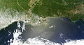
The Deepwater Horizon oil spill oil slick as seen from space by NASA's Terra satellite on May 1, 2010.

The Deepwater Horizon oil slick just off the Louisiana coast on April 30, 2010, visible from space.
Hurricane Karl, the most destructive hurricane of the 2010 Atlantic Hurricane Season, approaches Mexico on September 16.

Satellite image of Sweden in March 2002.
Satellite image of the Ash distribution over Australia from the 2022 Hunga Tonga–Hunga Ha'apai eruption.

Animation of Terra's orbit around the Earth. Earth is not shown.
