
Western Cape
The Western Cape (Afrikaans: Wes-Kaap [ˈvɛskɑːp]; Xhosa: iNtshona-Koloni) is a province of South Africa, situated on the south-western coast of the country. It is the fourth largest of the nine provinces with an area of 129,449 square kilometres (49,981 sq mi), and the third most populous, with an estimated 7 million inhabitants in 2020.[6] About two-thirds of these inhabitants live in the metropolitan area of Cape Town, which is also the provincial capital. The Western Cape was created in 1994 from part of the former Cape Province. The two largest cities are Cape Town and George.
For other uses, see West Cape.
Western Cape
27 April 1994
Alan Winde (DA)
129,462 km2 (49,986 sq mi)
2,325 m (7,628 ft)
0 m (0 ft)
7,433,020
57/km2 (150/sq mi)
42.1%
38.8%
16.4%
1.1%
41.2%
31.4%
22.0%
ZA-WC
![]() 0.58 [5]
0.58 [5]
high
iNtshona-Koloni
Wes-Kaap
Kapa Bodikela
Kapa Bophirimela
Kapa Bophirima
Kapa Vupela-dyambu
Kapa Vhukovhela
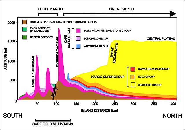
A diagrammatic 400 km south–north crosssection through the Cape at approximately 21° 30' E (i.e. near Calitzdorp in the Little Karoo), showing the relationship between the Cape Fold Mountains (and their geological structure) and the geology of the Little and Great Karoo, as well as the position of the Great Escarpment. The colour code for the geological layers is the same as those used in the diagram above. The heavy black line flanked by opposing arrows is the fault that runs for nearly 300 km along the southern edge of the Swartberg Mountains. The Swartberg Mountain range owes some of its great height to upliftment along this fault line. The subsurface structures are not to scale.
The Western Cape province has the most highly educated residents with a very skilled workforce in comparison to any other African region.[56] The high school graduation rate is consistently around 80%, higher than any other province. The proportion of adults with a degree or higher was 4.8% (2005),[47] the highest in the country.
The province also boasts four universities:
The province is also home to the South African Military Academy.