Katana VentraIP

Chesapeake and Ohio Canal

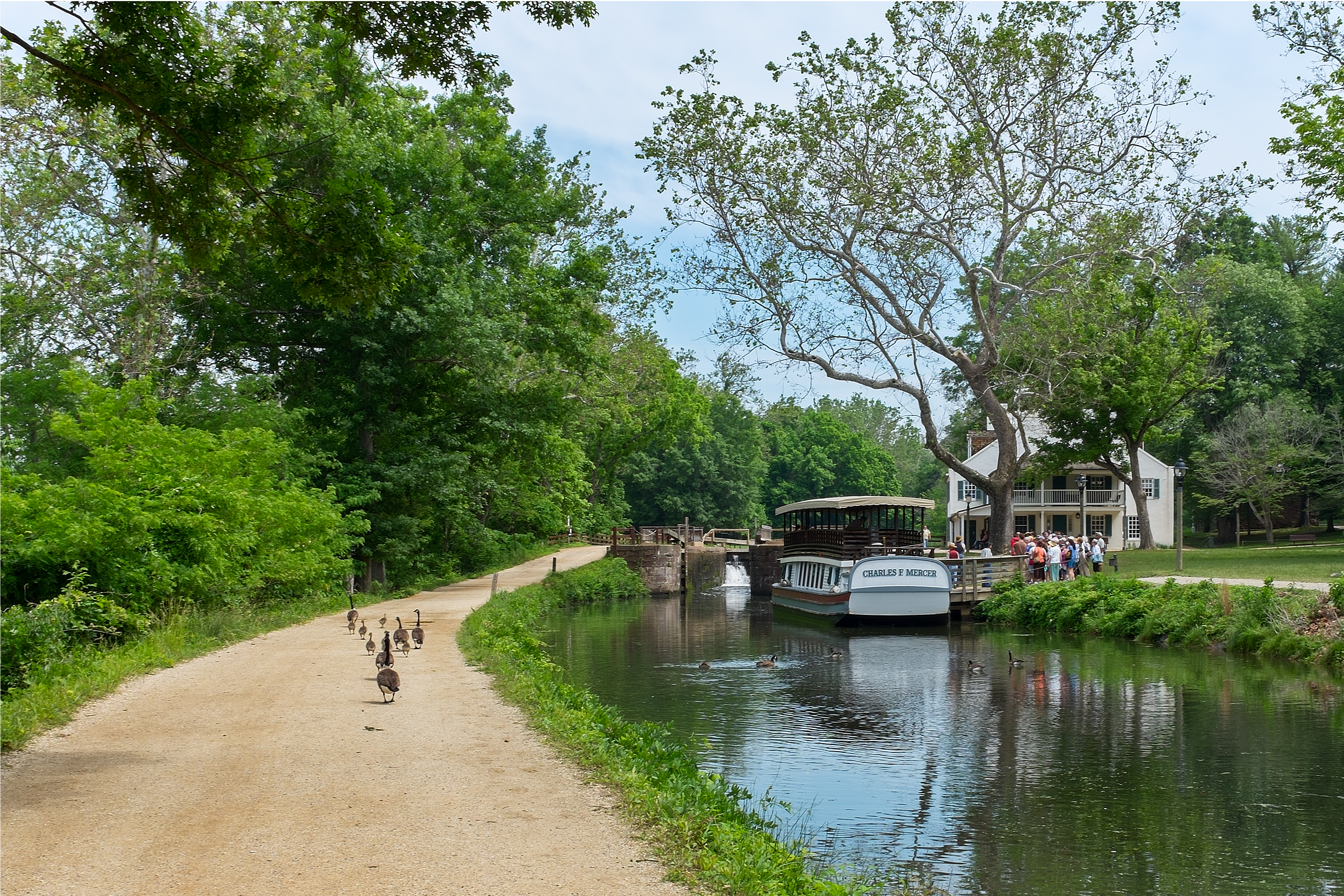
The Chesapeake and Ohio Canal, abbreviated as the C&O Canal and occasionally called the Grand Old Ditch,[1] operated from 1831 until 1924 along the Potomac River between Washington, D.C. and Cumberland, Maryland. It replaced the Potomac Canal, which shut down completely in 1828, and could operate during months in which the water level was too low for the former canal. The canal's principal cargo was coal from the Allegheny Mountains.

Chesapeake and Ohio Canal

184.5 miles (296.9 km)

90 ft 0 in (27.43 m)

14 ft 6 in (4.42 m)

74
(Boats must pass guard locks 4 & 5 for each trip.)

National Park

Chesapeake and Ohio Canal Company

Charles B. Fisk, William Rich Hutton

1825 (1825)

1828 (1828)

1830 (1830)

1850 (1850)

1924 (1924)

Georgetown, Washington, D.C.
(originally Little Falls Branch)
(Canal extended down to Georgetown in 1830)

Alexandria Canal (Virginia), Goose Creek, and Little River Navigation

Construction began in 1828 on the 184.5-mile (296.9 km) canal and ended in 1850 with the completion of a 50-mile (80 km) stretch to Cumberland, although the Baltimore and Ohio Railroad had already reached Cumberland in 1842. The canal had an elevation change of 605 feet (184 meters) which required 74 canal locks, 11 aqueducts to cross major streams, more than 240 culverts to cross smaller streams, and the 3,118 ft (950 m) Paw Paw Tunnel. A planned section to the Ohio River at Pittsburgh was never built.


The canal is now maintained as the Chesapeake and Ohio Canal National Historical Park, with a trail that follows the old towpath.

History[edit]

Early river projects[edit]

After the American Revolutionary War, George Washington was the chief advocate of using waterways to connect the Eastern Seaboard to the Great Lakes and the Ohio River, which flows into the Mississippi River and ultimately to the Gulf of Mexico at New Orleans.[2] In 1785, Washington founded the Potowmack Company to improve the navigability of the Potomac River. His company built five skirting canals around the major falls: Little Falls (later incorporated in the C&O Canal), Great Falls in Virginia, Seneca Falls (opposite Violette's lock), Payne's Falls of the Shenandoah, and House's Falls near Harpers Ferry.[3] These canals allowed an easy downstream float; upstream journeys, propelled by pole, were harder.


Several kinds of watercraft were used on the Patowmack Canal and in the Potomac River. Gondolas were 60 by 10 ft (18 by 3 m) log rafts, usually sold at journey's end for their wood by their owners, who returned upstream on foot. Sharpers were flat-bottomed boats, 60 by 7 ft (18 by 2 m), usable only on high-water days, about 45 days per year.[4]

May 30, 1877, Capt. Thomas Fisher fined $10 (about US$423 in 2012) for passing through lock without waybill

Oct 22, 1877, R. Cropley's scow, fined $25 for knocking out gate in Lock No. 5 [Brookmont Lock]

Nov. 12, 1877, Capt. Joseph Little, fined $10 for running into crib at Lock No. 9 [Seven Locks]

July 4, 1878, Boat John Sherman, fined $62.70 for unloading and raising (note: this was on Independence Day)

Aug 30, 1878, Steamer Scrivenes, fined $50, Allowing the Bertha M. Young in tow to sink on Level 36 and abandoning her at night without giving notice, causing navigation to be suspended 36 hrs.

May 5, 1879, Capt. Jacob Hooker fined $40, Running into and breaking gate at Lock No. 40

Jan 14, 1880, Boat Harry & Ralph, fined $5, Running into gate at Darbey's Lock (Note: this was in winter, when the canal was usually drained for repairs.)

Jun 12, 1880, G.L. Booth, fined $4.40, for pumping.

Locks and engineering[edit]

Canal prism[edit]

The dimensions of the canal vary quite a bit. Below Lock 5, the width is 80 feet wide and 6 feet deep.[89] Above Lock 5 to Harper's Ferry it is 60 feet wide and 6 feet deep, and above Harper's Ferry, 50 feet wide.[90]

for passengers

Packet Boats

Freight boats

especially work scows for construction and maintenance, as well as ice breaking[134]

Scows

Gondolas

On the 9 mile level around the 33–34 mile mark, some boats were used to transport soldiers to the during the American Civil War. One of the boats sank, and it was said that departed ghosts of the soldiers haunted the area. Canallers would avoid tying up at night in that area.[179] It was also said that the mules would sense it, and would hurry through the area (it was also called "Haunted House Bend"), and also that there were tales of a ghost dog there.[180]

Battle of Ball's Bluff

There was reported the ghost of an Indian chief on the 14 mile level around Big Pool.

[180]

A lady ghost was reported on the 2 mile level at Catoctin (between locks 28 and 29) which would walk over the waste weir, down the towpath and to the river.

[180]

A headless man was reported to haunt the .[181]

Paw Paw Tunnel

A like-story was documented near Lock 69 (Twigg's lock). (See Locks on the C&O Canal#Lock names for more info).

Romeo and Juliet

Many legends have been documented along the canal during its operating days:

Butcher, Russell D. (1997). Exploring Our National Historic Parks and Sites. Roberts Rinehart Publishers

National Park Service. Retrieved 2010-05-11.

Chesapeake and Ohio Canal National Historical Park.

Official National Park Service Site

at the University of Maryland libraries

Chesapeake and Ohio Canal Company records

Special Collections Research Center, Estelle and Melvin Gelman Library, The George Washington University.

Jack Rottier photographs and papers of the C and O Canal Online Collection

C&O Canal Trust

C&O Canal Association

The economic impact of the C&O Canal on canal communities in Washington County, Maryland

Special Collections Research Center, Estelle and Melvin Gelman Library, The George Washington University

Preliminary Guide to the Thomas Hahn Chesapeake and Ohio Canal Collection, 1939-1993

Documentary produced by WETA-TV

The Chesapeake and Ohio Canal

C&O Canal is part of the

Chesapeake Bay Gateways and Watertrails Network

- A National Park Service Teaching with Historic Places (TwHP) lesson plan

The Building of the Chesapeake and Ohio Canal

(HAER) No. MD-23, "Potomac Edison Company, Chesapeake & Ohio Canal Bridge, Spanning C & O Canal South of U.S. 11, Williamsport, Washington County, MD", 13 photos, 10 measured drawings, 19 data pages, 3 photo caption pages

Historic American Engineering Record

HAER No. MD-24, "", 1 photo, 2 measured drawings, 2 data pages, 1 photo caption page

Salisbury Street Bridge, Spanning C&O Canal (Milepost 99.65) & WM Railroad, Williamsport, Washington County, MD

HAER No. MD-26, "", 1 measured drawing

Chesapeake & Ohio Canal, Lockhouse 75, State Route 51 & Patterson Creek, Cumberland, Allegany County, MD

HAER No. MD-27-C, "", 1 measured drawing

Chesapeake & Ohio Canal, Salty Dog Tavern, Lock 33 vicinity, Sharpsburg, Washington County, MD

HAER No. MD-28, "", 3 measured drawings

Chesapeake & Ohio Canal, Mule Barn, Four Lock Road, Clear Spring, Washington County, MD

HAER No. MD-69, "", 4 photos, 5 data pages, 1 photo caption page

Chesapeake & Ohio Canal, White's Ferry Iron Bridge, Mile 35.49 of C & O Canal National Park, Martinsburg, Montgomery County, MD

HAER No. MD-70, "", 5 photos, 1 color transparency, 6 data pages, 2 photo caption pages

Chesapeake & Ohio Canal, Iron Bridge at Lock No. 68, Mile 164.82 of C & O Canal National Park, Oldtown, Allegany County, MD

HAER No. MD-71, "", 2 photos, 8 data pages, 1 photo caption page

Chesapeake & Ohio Canal, McCoy's Ferry Road Culvert, Mile 110.42 of C & O Canal National Park, Big Spring, Washington County, MD

HAER No. MD-72, "", 3 photos, 8 data pages, 1 photo caption page

Chesapeake & Ohio Canal, Prather's Neck Road Culvert, Mile 108.74 of C & O Canal National Park, Big Spring, Washington County, MD