China–Vietnam border
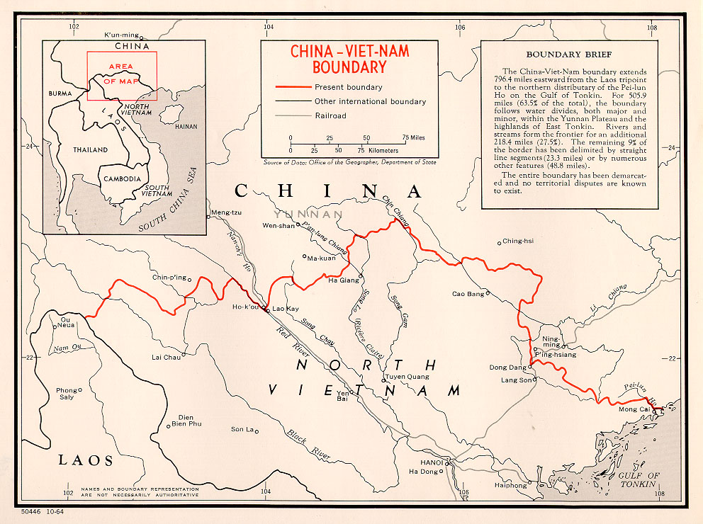
The China–Vietnam border is the international boundary between China and Vietnam, consisting of a 1,297 km (806 mi) terrestrial border stretching from the tripoint with Laos in the west to the Gulf of Tonkin coast in the east, and a maritime border in the Gulf of Tonkin and South China Sea.[1]
While disputes over the terrestrial border have been settled with the signing of a land boundary treaty between the two countries, the maritime border is currently undefined due to disputes over the ownership of territorial waters and islands, including the Spratly and Paracel Islands.[2][1]
History[edit]
Ancient[edit]
The border region has a long history. China under the Han dynasty had established control over Nam Việt (northern Vietnam) by the early 1st century BC.[4][5] The Vietnamese of Tonkin managed to break free of Han rule in 939 AD, forming the kingdom of Đại Việt.[6][4] An initial boundary between the two kingdoms at roughly its present location was established in the aftermath of the Lý–Song War (1075–1077).[7] Thereafter relations were largely peaceful, save for a 20 year occupation of northern Vietnam by Ming China in the 15th century.[4][8][9]
China and Vietnam signed an agreement on border trade in 1991. In 1992, 21 border trade points (cross border markets and goods import/export but limited through access for people) were opened, of which four also served as border crossings.[28] Vietnamese living in the border region may enter China using a one-day border pass that reduces wait at Chinese customs.[29]
The major border crossings are highlighted in bold; from west to east they are:
There are two rail crossings:[4]

Central

East
China–Vietnam border rivers

China–Vietnam border

Historical maps of the border from west to east in the