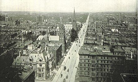
Fifth Avenue
Fifth Avenue is a major and prominent thoroughfare in the borough of Manhattan in New York City, New York, United States. It stretches north from Washington Square Park in Greenwich Village to West 143rd Street in Harlem. It is one of the most expensive shopping streets in the world.[3][4]
For other uses, see Fifth Avenue (disambiguation).Owner
Madison Square in Flatiron
Grand Army Plaza in Midtown
Duke Ellington Circle in East Harlem
Marcus Garvey Park in Harlem
Madison Avenue Bridge in Harlem![]() Harlem River Drive in Harlem
Harlem River Drive in Harlem
![]() Harlem River Drive / 143rd Street in Harlem
Harlem River Drive / 143rd Street in Harlem
University Place (south of 14th)
Broadway (14th to 23rd)
Madison Avenue (north of 23rd)
Sixth Avenue (south of 59th)
Central Park-East Drive (59th to 110th)
Lenox Avenue (north of 110th)
Fifth Avenue carries two-way traffic from 142nd to 135th Street and carries one-way traffic southbound for the remainder of its route. The entire street used to carry two-way traffic until 1966. From 124th to 120th Street, Fifth Avenue is cut off by Marcus Garvey Park, with southbound traffic diverted around the park via Mount Morris Park West and northbound to Madison Avenue. Most of the avenue has a bus lane, though not a bike lane. Fifth Avenue is the traditional route for many celebratory parades in New York City, and is closed on several Sundays per year.
Fifth Avenue was originally only a narrower thoroughfare but the section south of Central Park was widened in 1908. The midtown blocks between 34th and 59th Streets were largely a residential area until the turn of the 20th century, when they were developed as commercial areas. The section of Fifth Avenue in the 50s is consistently ranked among the most expensive shopping streets in the world, and the section between 59th and 96th Streets across Central Park was nicknamed "Millionaire's Row" in the early 20th century due to the high concentration of mansions there. A section of Fifth Avenue running from 82nd to 110th Streets, also alongside Central Park, is also nicknamed Museum Mile due to the large number of museums there.
History[edit]
Early history[edit]
Fifth Avenue between 42nd Street and Central Park South (59th Street) was relatively undeveloped through the late 19th century.[5]: 2 The surrounding area was once part of the common lands of the city of New York, which was allocated "all the waste, vacant, unpatented, and unappropriated lands" as a result of the 1686 Dongan Charter.[6] The city's Common Council came to own a large amount of land, primarily in the middle of the island away from the Hudson and East Rivers, as a result of grants by the Dutch provincial government to the colony of New Amsterdam. Although originally more extensive, by 1785 the council held approximately 1,300 acres (530 ha), or about 9 percent of the island.[7]
The lots along what is now Fifth Avenue were laid out in the late 18th century following the American Revolutionary War.[5]: 2 The city's Common Council had, starting in June 1785, attempted to raise money by selling property. The land that the Council owned was not suitable for farming or residential estates, and it was also far away from any roads or waterways.[7] To divide the common lands into sellable lots, and to lay out roads to service them, the Council hired Casimir Goerck to survey them. Goerck was instructed to make lots of about 5 acres (2.0 ha) each and to lay out roads to access the lots. He completed his task in December 1785, creating 140 lots of varying sizes, oriented with the east–west axis longer than the north–south axis.[7] As part of the plan, Goerck drew up a street called Middle Road, which eventually became Fifth Avenue.[7][8][9]
The topography of the lots contributed to the public's reluctance to buy the lots. By 1794, with the city growing ever more populated and the inhabited area constantly moving north towards the Common Lands, the Council decided to try again, hiring Goerck once more to re-survey and map the area. He was instructed to make the lots more uniform and rectangular and to lay out roads to the west and east of Middle Road, as well as to lay out east–west streets of 60 feet (18 m) each. Goerck's East and West Roads later became Fourth and Sixth Avenues, while Goerck's cross streets became the modern-day numbered east–west streets. Goerck took two years to survey the 212 lots which encompassed the entire Common Lands.[7] The Commissioners' Plan of 1811, which prescribed the street plan for Manhattan, was heavily inspired from Goerck's two surveys.[5]: 9
Notes
Further reading


