
Meroë
Meroë (/ˈmɛroʊiː/;[1] also spelled Meroe;[2] Meroitic: Medewi; Arabic: مرواه, romanized: Meruwah and مروي, Meruwi; Ancient Greek: Μερόη, romanized: Meróē) was an ancient city on the east bank of the Nile about 6 km north-east of the Kabushiya station near Shendi, Sudan, approximately 200 km north-east of Khartoum. Near the site is a group of villages called Bagrawiyah (Arabic: البجراوية). This city was the capital of the Kingdom of Kush for several centuries from around 590 BC, until its collapse in the 4th century AD. The Kushitic Kingdom of Meroë gave its name to the "Island of Meroë", which was the modern region of Butana, a region bounded by the Nile (from the Atbarah River to Khartoum), the Atbarah and the Blue Nile.
Not to be confused with Merowe, Sudan.Alternative name
Meroe
Settlement
Archaeological Sites of the Island of Meroe
Cultural
ii, iii, vi, v
2011 (35th session)
The city of Meroë was on the edge of Butana. There were two other Meroitic cities in Butana: Musawwarat es-Sufra and Naqa.[3][4] The first of these sites was given the name Meroë by the Persian king Cambyses, in honor of his sister who was called by that name. The city had originally borne the ancient appellation Saba, named after the country's original founder.[5] The eponym Saba, or Seba, is named for one of the sons of Cush (see Genesis 10:7). The presence of numerous Meroitic sites within the western Butana region and on the border of Butana proper is significant to the settlement of the core of the developed region. The orientation of these settlements exhibit the exercise of state power over subsistence production.[6]
The Kingdom of Kush which housed the city of Meroë represents one of a series of early states located within the middle Nile. It was one of the earliest and most advanced states found on the African continent. Looking at the specificity of the surrounding early states within the middle Nile, one's understanding of Meroë in combination with the historical developments of other historic states may be enhanced through looking at the development of power relation characteristics within other Nile Valley states.[6]
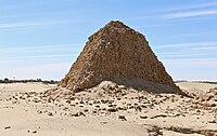
The site of the city of Meroë is marked by more than two hundred pyramids in three groups, of which many are in ruins. They have the distinctive size and proportions of Nubian pyramids.
Jewelry found on the mummy of Nubian King Amaninatakilebte (538–519 BC). Museum of Fine Arts, Boston.


Meroë in Jewish legend[edit]
Jewish oral tradition avers that Moses, in his younger years, had led an Egyptian military expedition into Sudan (Kush), as far as the city of Meroë, which was then called Saba. The city was built near the confluence of two great rivers and was encircled by a formidable wall, and governed by a renegade king. To ensure the safety of his men who traversed that desert country, Moses had invented a stratagem whereby the Egyptian army would carry along with them baskets of sedge, each containing an ibis, only to be released when they approached the enemy's country. The purpose of the birds was to kill the deadly serpents that lay all about that country.[5] Having successfully laid siege to the city, the city was eventually subdued by the betrayal of the king's daughter, who had agreed to deliver the city to Moses on condition that he would consummate a marriage with her, under the solemn assurance of an oath.[a]
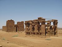
Colonnade of rams in front of Amun-Ra temple in Naqa

The site of Meroë was brought to the knowledge of Europeans in 1821 by the French mineralogist Frédéric Cailliaud (1787–1869), who published an illustrated in-folio describing the ruins. His work included the first publication of the southernmost known Latin inscription.[b]
As Margoliouth notes in the 1911 Encyclopedia Britannica, small scale excavations occurred in 1834, led by Giuseppe Ferlini,[2] who, as Margoliouth states, "discovered (or professed to discover) various antiquities, chiefly in the form of jewelry, now in the museums of Berlin and Munich."[2] Margoliouth continues,