Northwest Ordinance
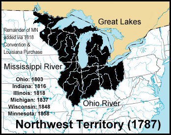
The Northwest Ordinance (formally An Ordinance for the Government of the Territory of the United States, North-West of the River Ohio and also known as the Ordinance of 1787), enacted July 13, 1787, was an organic act of the Congress of the Confederation of the United States. It created the Northwest Territory, the new nation's first organized incorporated territory, from lands beyond the Appalachian Mountains, between British North America and the Great Lakes to the north and the Ohio River to the south. The upper Mississippi River formed the territory's western boundary. Pennsylvania was the eastern boundary.
In the 1783 Treaty of Paris, which formally ended the American Revolutionary War, Great Britain ceded the region to the United States. However, the Confederation Congress faced numerous problems gaining control of the land such as the unsanctioned movement of American settlers into the Ohio Valley; violent resistance from the region's indigenous peoples; the continued presence of British outposts in the region and an empty U.S. treasury.[1] The ordinance superseded the Land Ordinance of 1784, which declared that states would one day be formed within the region, and the Land Ordinance of 1785, which described how the Confederation Congress would sell the land to private citizens. Designed to serve as a plan for the development and settlement of the region, the 1787 ordinance lacked a strong central government to implement it. That need was addressed shortly with the formation of the U.S. federal government in 1789. The First Congress reaffirmed the 1787 ordinance and, with slight modifications, renewed it with the Northwest Ordinance of 1789.[2]
Considered one of the most important legislative acts of the Confederation Congress,[3] it established the precedent by which the federal government would be sovereign and expand westward with the admission of new states, rather than with the expansion of existing states and their established sovereignty under the Articles of Confederation. It also set legislative precedent with regard to American public domain lands.[4] The U.S. Supreme Court recognized the authority of the Northwest Ordinance of 1789 within the applicable Northwest Territory as constitutional in Strader v. Graham,[5] but it did not extend the ordinance to cover the respective states once they were admitted to the Union.
The prohibition of slavery in the territory had the practical effect of establishing the Ohio River as the geographic divide between slave states and free states from the Appalachian Mountains to the Mississippi River, an extension of the Mason–Dixon line. It also helped set the stage for later federal political conflicts over slavery during the 19th century until the American Civil War.[6]