Timbuktu
Timbuktu (/ˌtɪmbʌkˈtuː/ TIM-buk-TOO; French: Tombouctou; Koyra Chiini: Tumbutu; Tuareg: ⵜⵏⵀⵗⵜ, romanized: Tin Bukt) is an ancient city in Mali, situated 20 kilometres (12 miles) north of the Niger River. It is the capital of the Tombouctou Region, one of the eight administrative regions of Mali, having a population of 54,453 in the 2009 census.
For other uses, see Timbuktu (disambiguation).
Timbuktu
Himba
ⵜⵏⵀⵗⵜ
تِينْ بُكْتْ
تُمْبُتُ
5th century BCE
261 m (856 ft)
30,000
Cultural: ii, iv, v
1988 (12th Session)
1990–2005; 2012–present
Archaeological evidence suggests prehistoric settlements in the region, predating the city's Islamic scholarly and trade prominence in the medieval period. Timbuktu began as a seasonal settlement and became permanent early in the 12th century. After a shift in trading routes, particularly after the visit by Mansa Musa around 1325, Timbuktu flourished, due to its strategic location, from the trade in salt, gold, and ivory. It gradually expanded as an important Islamic city on the Saharan trade route and attracted many scholars and traders before it became part of the Mali Empire early in the 14th century. In the first half of the 15th century, the Tuareg people took control for a short period, until the expanding Songhai Empire absorbed it in 1468.
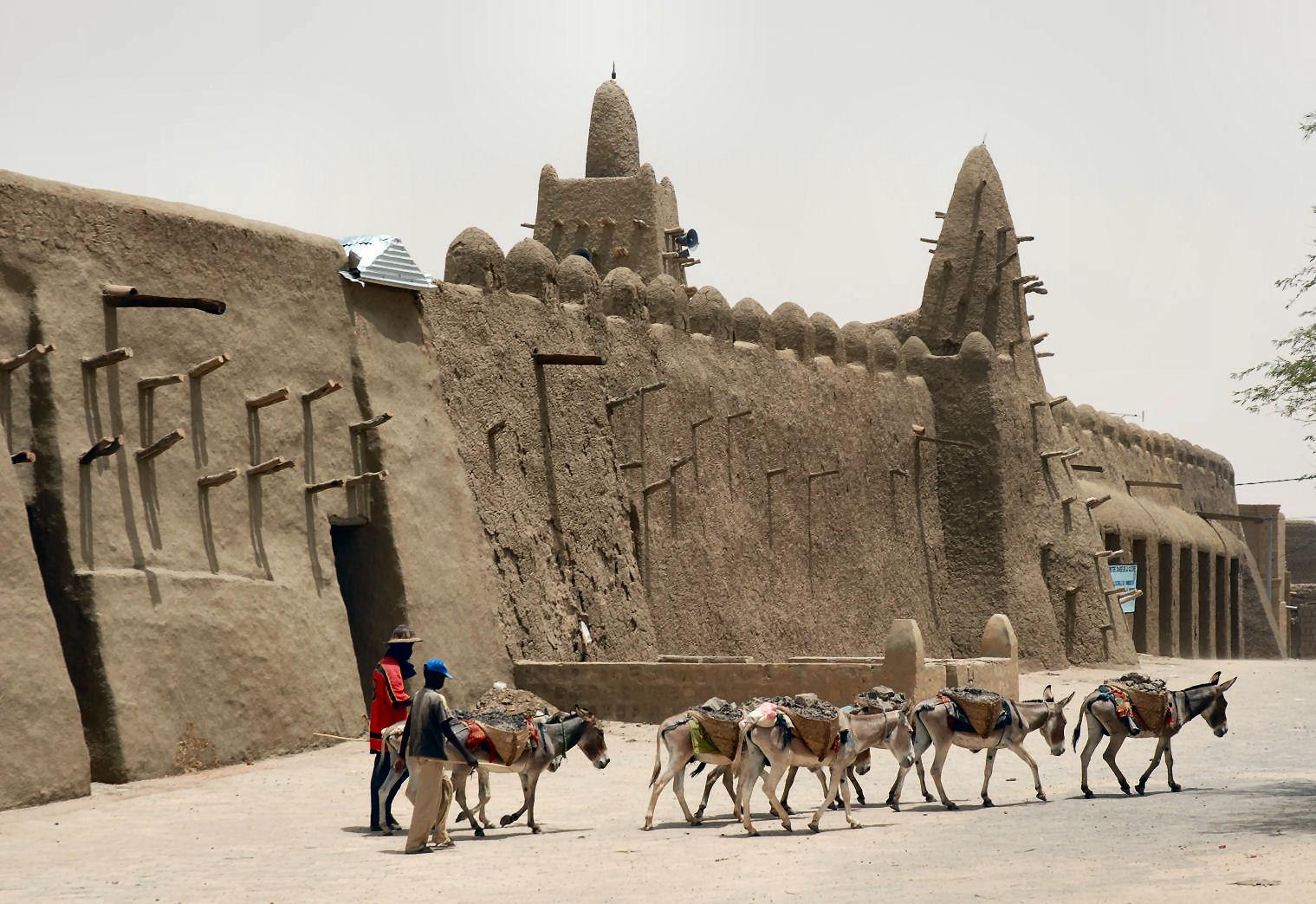
A Moroccan army defeated the Songhai in 1591 and made Timbuktu their capital. The invaders established a new ruling class, the Arma, who after 1612 became virtually independent of Morocco. In its golden age, the town's Islamic scholars and extensive trade network supported an important book trade. Together with the campuses of the Sankore Madrasah, an Islamic university, this established Timbuktu as a scholarly centre in Africa. Notable historic writers, such as Shabeni and Leo Africanus, wrote about the city. These stories fuelled speculation in Europe, where the city's reputation shifted from being rich to mysterious. The city's golden age as a major learning and cultural centre of the Mali Empire was followed by a long period of decline. Different tribes governed until the French took over Mali in 1893, in a regime that lasted until the country became the Republic of Mali in 1960.
In recent history, Timbuktu faced threats from extremist groups leading to the destruction of cultural sites; efforts by local and international communities have aimed to preserve its heritage. The city's population has declined as a result of the recent issues.
Over the centuries, the spelling of Timbuktu has varied a great deal: from Tenbuch on the Catalan Atlas (1375), to traveller Antonio Malfante's Thambet, used in a letter he wrote in 1447 and also adopted by Alvise Cadamosto in his Voyages of Cadamosto, to Heinrich Barth's Timbúktu and Timbu'ktu. French spelling often appears in international reference as 'Tombouctou'. The German spelling 'Timbuktu' and its variant 'Timbucktu' have passed into English and the former has become widely used in recent years. Major English-language works have employed the spelling 'Timbuctoo', and this is considered the correct English form by scholars; 'Timbuctou' and 'Timbuctu' are sometimes used as well.
The French continue to use the spelling 'Tombouctou', as they have for over a century; variants include 'Temboctou' (used by explorer René Caillié) and 'Tombouktou', but they are seldom seen. Variant spellings exist for other places as well, such as Jenne (Djenné) and Segu (Ségou).[2] As well as its spelling, Timbuktu's toponymy is still open to discussion.[a] At least four possible origins of the name of Timbuktu have been described:
The validity of these theories depends on the identity of the original founders of the city: as recently as 2000, archaeological research has not found remains dating from the 11th/12th century within the limits of the modern city given the difficulty of excavating through metres of sand that have buried the remains over the past centuries.[9][10] Without consensus, the etymology of Timbuktu remains unclear.
Prehistory[edit]
Like other important Medieval West African towns such as Djenné (Jenné-Jeno), Gao, and Dia, Iron Age settlements have been discovered near Timbuktu that predate the traditional foundation date of the town. Although the accumulation of thick layers of sand has thwarted archaeological excavations in the town itself,[11][10] some of the surrounding landscape is deflating and exposing pottery shards on the surface. A survey of the area by Susan and Roderick McIntosh in 1984 identified several Iron Age sites along the el-Ahmar, an ancient wadi system that passes a few kilometers to the east of the modern town.[12]
An Iron Age tell complex located nine kilometres (5+1⁄2 mi) southeast of the Timbuktu near the Wadi el-Ahmar was excavated between 2008 and 2010 by archaeologists from Yale University and the Mission Culturelle de Tombouctou. The results suggest that the site was first occupied during the 5th century BC, thrived throughout the second half of the 1st millennium AD and eventually collapsed sometime during the late 10th or early 11th-century AD.[13][14]
Infrastructure[edit]
With no railroads in Mali except for the Dakar-Niger Railway up to Koulikoro, access to Timbuktu is by road, boat or, since 1961, aircraft.[116] With high water levels in the Niger from August to December, Compagnie Malienne de Navigation (COMANAV) passenger ferries operate a leg between Koulikoro and downstream Gao on a roughly weekly basis. Also requiring high water are pinasses (large motorized pirogues), either chartered or public, that travel up and down the river.[117]
Both ferries and pinasses arrive at Korioumé, Timbuktu's port, which is linked to the city centre by an 18 km (11 mi) paved road running through Kabara. In 2007, access to Timbuktu's traditional port, Kabara, was restored by a Libyan funded project that dredged the 3 km (2 mi) silted canal connecting Kabara to an arm of the Niger River. COMANAV ferries and pinasses are now able to reach the port when the river is in full flood.[21][118]
Timbuktu is poorly connected to the Malian road network with only dirt roads to the neighbouring towns. Although the Niger River can be crossed by ferry at Korioumé, the roads south of the river are no better. However, a new paved road is under construction between Niono and Timbuktu running to the north of the Inland Niger Delta. The 565 km (351 mi) road will pass through Nampala, Léré, Niafunké, Tonka, Diré and Goundam.[119][120] The completed 81 km (50 mi) section between Niono and the small village of Goma Coura was financed by the Millennium Challenge Corporation.[121] This new section will service the Alatona irrigation system development of the Office du Niger.[122] The 484 km (301 mi) section between Goma Coura and Timbuktu is being financed by the European Development Fund.[119]
Timbuktu Airport was served by Air Mali, hosting flights to and from Bamako, Gao and Mopti.[117] until the airline suspended operations in 2014. Its 6,923 ft (2,110 m) runway in a 07/25 runway orientation is both lighted and paved.[123]
Currently (July 2023), Timbuktu Airport is served by Sky Mali to and from Bamako, using Boeing 737 aircraft.
In popular culture[edit]
Because much of the gold in Europe in the seventeenth and eighteenth centuries came from Timbuktu, the city has long been considered a mysterious, hidden place.[31] This association remains with modern Europeans and North Americans: a 2006 survey of 150 young Britons found that 34% did not believe the town existed, while the other 66% considered it "a mythical place".[124] This perception has been acknowledged in literature describing African history and African-European relations. In popular Western culture, Timbuktu is also often considered an idiomatic stand-in for any faraway place.[3][125][126]
The origin of this mystification lies in the excitement brought to Europe by the legendary tales, especially those by Leo Africanus in his Description of Africa. Arabic sources focused mainly on more affluent cities in the Timbuktu region, such as Gao and Walata.[10] In West Africa, the city holds an image that has been compared to Europe's view on Athens.[125] As such, the picture of the city as the epitome of distance and mystery is a European one.[3]
Down-to-earth-aspects in Africanus' descriptions were largely ignored and stories of great riches served as a catalyst for travellers to visit the inaccessible city, with prominent French explorer René Caillié characterising Timbuktu as "a mass of ill-looking houses built of earth".[127] Now opened up, many travellers acknowledged the unfitting description of an "African El Dorado".[31] This development shifted the city's reputation, from being fabled because of its gold to fabled because of its location and mystery. Being used in this sense since at least 1863, English dictionaries now cite Timbuktu as a metaphor for any faraway place.[128]
Timbuktu plays a vital role in Dorothy Dunnett's House of Niccolo series of historical novels, as a physical setting in Scales of Gold,[129] and as a spiritual and intellectual influence throughout, through the character of Umar, a man from that city enslaved in Europe under the name Loppe, and his friendship with Nicholas, the central character of the series.
The musical Timbuktu! premiered on Broadway on March 1, 1978. With lyrics by George Forrest and Robert Wright, set to music by Borodin, Forrest and Wright and a book by Luther Davis, it is a retelling of Forrest and Wright's musical Kismet, changing the setting to mid-14th century Timbuktu. It starred Eartha Kitt, William Marshall, Gilbert Price, Melba Moore and George Bell. Geoffrey Holder was director, choreographer and costume designer.