Turbot (pronounced 'terbet', not 'turbo') Street is not part of naming series of female British royalty used for the other parallel streets in the CBD.[1][2] Turbot was an indigenous word used by the local Turrbal people.[3]
corner with (right-side) – Inns of Court facility. First purchased in 1960 by the Barristers Chambers Limited, the building consisted of some 60 chambers. In the mid-1980s, it was replaced by a twenty-level Inns of Court[49]
North Quay
corner with North Quay – former site of the Adult Deaf and Dumb Institute, later the Queensland Deaf Society (opened 1918)
[50]
former site of the Richmond Villa , near North Quay. Operated by Mrs Raphael Lewin (1870s–1906), Mrs Bartley (1906–), until at least 1934 with Annie Kelly.[51] By 1946, owned by the Independent Order of Rechabites, the site was sold to McDonnell & East for future expansion, for £5000[52]
boarding establishment
former site of the Marlborough House boarding establishment, near North Quay (1900s), as well as Ashford Villa (1886) near North Quay, and Mrs Lowther's Clare Cottage (1884) near George Street
32 Turbot Street (left-side) – (2009) was formerly a warehouse and laneway for McDonnell & East merchant store. Prior to this, the site was Adam Fiebig's two-story Crown Hotel[53]
Santos Place
33 Turbot Street (right-side) – former site of The Hawaiian Eye and The Manor (1960s)[54]
nightclubs
former location of Kelly's British Empire Hotel (ca. 1865), at the intersection with .[55] The new hotel included seven large bedrooms, dining rooms, parlours, and stables[56]
George Street
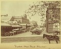
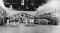
Fruit and produce market building in Turbot Street, circa 1910former Turbot Street Fruit Market site as part of the Brisbane Fruit and Produce Exchange, with a building frontage of 198 feet (60 m).[57] Opened in 1906, wholesalers established a market as a rival to the nearby municipally-regulated Roma Street Markets, until the creation in 1964 of the Rocklea markets.[58] Due to the traffic congestion, it was proposed to move both the Roma Street and Turbot Street markets, possibly towards Countess Street on the other side of the railway yards[59]
corner with 331 George Street (SE corner; right-side) – , built from 1915 to 1916 (Queensland Heritage Register-listed)
Brisbane Associated Friendly Societies (BAFS) Building
corner with 363 George Street (NE corner; left-side) – (2004)
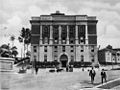
Brisbane Magistrates Court building
64 Turbot Street (left-side) – former site of The Open Door (1960s)[54]
nightclub
former location of the Female Refuge and Infants Home (1880–1918), also known as Mrs Drew's Home, until it was merged with Saint Mary's Home, Taringa, on the Toowong property in 1919[61]
[60]
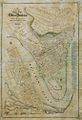
Many Brisbane landmarks are or were located on Turbot Street (as numbered, starting from the intersection at the Riverside Expressway):
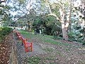
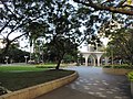
Named in honour of King Edward VII (1841–1910) in the early part of the 20th century, the one-acre parklands is part of the Wickham Park and Observatory Park recreation area green space that was part of Turbot Street to Wickham Terrace, Brisbane. While Wickham Park was owned by the municipal council, King Edward Park was state government land.[70] It is bounded to the east by Jacob's Ladder.
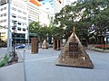
In February 1990, the park was reopened as a sculpture park. It contains art works by: