First Battle of Ypres
The First Battle of Ypres (French: Première Bataille des Flandres, German: Erste Flandernschlacht, 19 October – 22 November 1914) was a battle of the First World War, fought on the Western Front around Ypres, in West Flanders, Belgium. The battle was part of the First Battle of Flanders, in which German, French, Belgian armies and the British Expeditionary Force (BEF) fought from Arras in France to Nieuwpoort (Nieuport) on the Belgian coast, from 10 October to mid-November. The battles at Ypres began at the end of the Race to the Sea, reciprocal attempts by the German and Franco-British armies to advance past the northern flank of their opponents. North of Ypres, the fighting continued in the Battle of the Yser (16–31 October), between the German 4th Army, the Belgian army and French marines.
For a list of the Battles of Ypres, see Battle of Ypres.
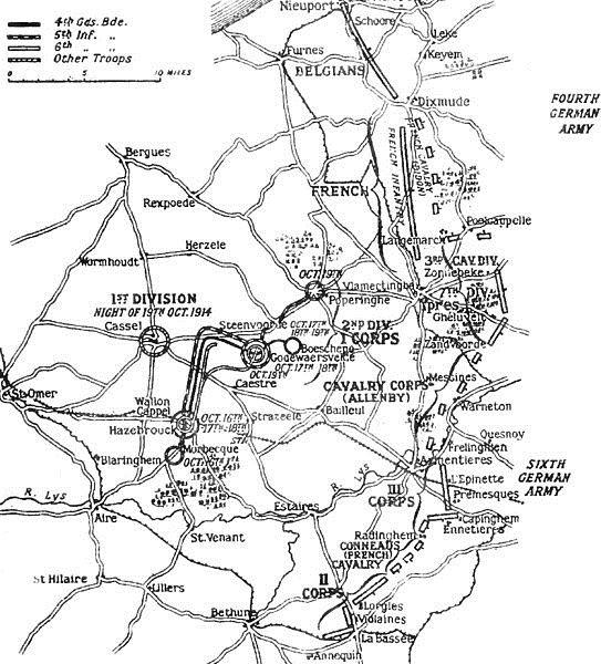
The fighting has been divided into five stages, an encounter battle from 19 to 21 October, the Battle of Langemarck from 21 to 24 October, the battles at La Bassée and Armentières to 2 November, coincident with more Allied attacks at Ypres and the Battle of Gheluvelt (29–31 October), a fourth phase with the last big German offensive, which culminated at the Battle of Nonne Bosschen on 11 November, then local operations which faded out in late November. Brigadier-General James Edmonds, the British official historian, wrote in the History of the Great War, that the II Corps battle at La Bassée could be taken as separate but that the battles from Armentières to Messines and Ypres, were better understood as one battle in two parts, an offensive by III Corps and the Cavalry Corps from 12 to 18 October against which the Germans retired and an offensive by the German 6th Army and 4th Army from 19 October to 2 November, which from 30 October, took place mainly north of the Lys, when the battles of Armentières and Messines merged with the Battles of Ypres.[a]
Attacks by the BEF (Field Marshal Sir John French) the Belgians and the French Eighth Army in Belgium made little progress beyond Ypres. The German 4th and 6th Armies took small amounts of ground, at great cost to both sides, during the Battle of the Yser and further south at Ypres. General Erich von Falkenhayn, head of the Oberste Heeresleitung (OHL, the German General Staff), then tried a limited offensive to capture Ypres and Mont Kemmel (Kemmelberg), from 19 October to 22 November. Neither side had moved forces to Flanders fast enough to obtain a decisive victory and by November both sides were exhausted. The armies were short of ammunition, suffering from low morale and some infantry units refused orders. The autumn battles in Flanders had become static, attrition operations, unlike the battles of manoeuvre in the summer. French, British and Belgian troops, in improvised field defences, repulsed German attacks for four weeks. From 21 to 23 October, German reservists had made mass attacks at Langemarck (Langemark), with losses of up to 70 per cent, to little effect.
Warfare between mass armies, equipped with the weapons of the Industrial Revolution and its later developments, proved to be indecisive, because field fortifications neutralised many classes of offensive weapon. The defensive firepower of artillery and machine guns dominated the battlefield and the ability of the armies to supply themselves and replace casualties prolonged battles for weeks. Thirty-four German divisions fought in the Flanders battles, against twelve French, nine British and six Belgian divisions, along with marines and dismounted cavalry. Over the winter, Falkenhayn reconsidered Germany strategy because Vernichtungsstrategie and the imposition of a dictated peace on France and Russia had exceeded German resources. Falkenhayn devised a new strategy to detach either Russia or France from the Allied coalition through diplomacy as well as military action. A strategy of attrition (Ermattungsstrategie) would make the cost of the war too great for the Allies, until one dropped out and made a separate peace. The remaining belligerents would have to negotiate or face the Germans concentrated on the remaining front, which would be sufficient for Germany to inflict a decisive defeat.
Prelude
Terrain
The far north of France and the north-west Belgium are known as Flanders. West of a line between Arras and Calais in the north-west are chalk downlands, covered with soil sufficient for arable farming. East of the line, the land declines in a series of spurs into the Flanders plain, bounded by canals linking Douai, Béthune, Saint-Omer and Calais. To the south-east, canals run between Lens, Lille, Roubaix and Courtrai, the Lys river from Courtrai to Ghent and to the north-west lies the sea. The plain is almost flat, apart from a line of low hills from Cassel, eastwards to Mont des Cats, Mont Noir, Mont Rouge, Scherpenberg and Mont Kemmel. From Kemmel, a low ridge lies to the north-east, declining in elevation past Ypres through Wytschaete (Wijtschate), Gheluvelt and Passchendaele (Passendale), curving north then north-west to Diksmuide where it merges with the plain. A coastal strip is about 10 mi (16 km) wide, near sea level and fringed by sand dunes. Inland the ground is mainly meadow, cut by canals, dykes, drainage ditches and roads built up on causeways. The Lys, Yser and upper Scheldt are canalised and between them, the water level underground is close to the surface, rises further in the autumn and fills any dip, the sides of which then collapse. The ground surface quickly turns to a consistency of cream cheese and on the coast movement is confined to roads, except during frosts.[28]
In the rest of the Flanders Plain were woods and small fields, divided by hedgerows planted with trees and fields cultivated from small villages and farms. The terrain was difficult for infantry operations because of the lack of observation, impossible for mounted action because of the many obstructions and awkward for artillery because of the limited view. South of La Bassée Canal around Lens and Béthune was a coal-mining district full of slagheaps, pitheads (fosses) and miners' houses (corons). North of the canal, the city of Lille, Tourcoing and Roubaix formed a manufacturing complex, with outlying industries at Armentières, Comines, Halluin and Menin (Menen), along the Lys river, with isolated sugar beet and alcohol refineries and a steelworks near Aire-sur-la-Lys. Intervening areas were agricultural, with wide roads, which in France were built on shallow foundations or were unpaved mud tracks. Narrow pavé roads ran along the frontier and inside Belgium. In France, the roads were closed by the local authorities during thaws to preserve the surface and marked by Barrières fermėes signs, which were ignored by British lorry drivers. The difficulty of movement after the end of summer absorbed much of the labour available on road maintenance, leaving field defences to be built by front-line soldiers.[29]
Tactics
In October, Herbert Kitchener, the British Secretary of State for War, forecast a long war and placed orders for the manufacture of a large number of field, medium and heavy guns and howitzers, sufficient to equip a 24-division army. The order was soon increased by the War Office but the rate of shell manufacture had an immediate effect on operations. While the BEF was still on the Aisne front, ammunition production for field guns and howitzers was 10,000 shells a month and only 100 shells per month were being manufactured for 60-pounder guns; the War Office sent another 101 heavy guns to France during October. As the contending armies moved north into Flanders, the flat terrain and obstructed view, caused by the number of buildings, industrial concerns, tree foliage and field boundaries, forced changes in British artillery methods. Lack of observation was remedied in part by decentralising artillery to infantry brigades and by locating the guns in the front line but this made them more vulnerable and several batteries were overrun in the fighting between Arras and Ypres. Devolving control of the guns made concentrated artillery-fire difficult to arrange, because of a lack of field telephones and the obscuring of signal flags by mists and fog.[30]
Co-operation with French forces to share the British heavy artillery was implemented and discussions with French gunners led to a synthesis of the French practice of firing a field artillery rafale (squall) before infantry moved to the attack and then ceasing fire, with the British preference for direct fire at observed targets, which was the beginning of the development of creeping barrages. During the advance of the III Corps and an attack on Méteren, the 4th Division issued divisional artillery orders, which stressed the concentration of the fire of the artillery, although during the battle the gunners fired on targets of opportunity, since German positions were so well camouflaged. As the fighting moved north into Belgian Flanders, the artillery found that Shrapnel shells had little effect on buildings and called for high explosive ammunition. During a general attack on 18 October, the German defenders achieved a defensive success, due to the disorganised nature of the British attacks, which only succeeded where close artillery support was available. The unexpected strength of the German 4th Army opposite, compounded British failings, although the partly trained, poorly led and badly equipped German reserve corps suffered high casualties.[31]
German tactics developed during the battles around Ypres, with cavalry still effective during the early manoeuvring, although just as hampered by hedges and fenced fields, railway lines and urban growth as the Allied cavalry, which made the ground far better suited to defensive battle. German accounts stress the accuracy of Allied sniper fire, which led troops to remove the spike from Pickelhaube helmets and for officers to carry rifles to be less conspicuous. Artillery remained the main infantry-killer, particularly French 75 mm field guns, firing shrapnel at ranges lower than 1,000 yd (910 m). Artillery in German reserve units was far less efficient, due to lack of training and shells often fell short.[32] In the lower ground between Ypres and the higher ground to the south-east and east, the ground was drained by many streams and ditches, divided into small fields with high hedges and ditches, roads were unpaved and the area was dotted with houses and farmsteads. Observation was limited by trees and open spaces could be commanded from covered positions and made untenable by small-arms and artillery fire. As winter approached, the views became more open as woods and copses were cut down by artillery bombardments and the ground became much softer, particularly in the lower-lying areas.[33]