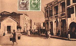
Leased Territory of Guangzhouwan
The Leased Territory of Guangzhouwan, officially the Territoire de Kouang-Tchéou-Wan,[nb 1] was a territory on the coast of Zhanjiang in China leased to France and administered by French Indochina.[1] The capital of the territory was Fort-Bayard, present-day Zhanjiang.[nb 2]
"Guangzhouwan" redirects here. Not to be confused with Guangzhou.
Kouang-Tchéou-Wan廣州灣
22 April 1898
29 May 1898
5 January 1900
21 February 1943
18 August 1945
189,000
209,000
廣州灣
广州湾
Guangzhou Bay
Guǎngzhōu wān
Guǎngzhōu wān
Kuang3 Chou1 Wan1
Gwong2 Zau1 Waan1
The Japanese occupied the territory in February 1943. In 1945, following the surrender of Japan, France formally relinquished Guangzhouwan to China. The territory did not experience the rapid growth in population that other parts of coastal China experienced, rising from 189,000 in the early 20th century[2] to just 209,000 in 1935.[3] Industries included shipping and coal mining.
Geography[edit]
The leased territory was situated on the east side of the Leizhou Peninsula (French: Péninsule de Leitcheou), near Guangzhou, around a bay then called Kwangchowan, now called the Port of Zhanjiang. The bay forms the estuary of the Maxie River (Chinese: 麻斜河; pinyin: Máxié hé, French: Rivière Ma-The), now known as the Zhanjiang Waterway (Chinese: 湛江水道; pinyin: Zhànjiāng shuǐdào).[4] The Maxie is navigable as far as 19 kilometres (12 mi) inland even by large warships.
The territory leased to France included the islands lying in the bay, which enclosed an area 29 km long by 10 km wide and a minimum water depth of 10 metres. The islands were recognized at the time as an admirable natural defense, the main islands being Donghai Dao. On the smaller Naozhou Island farther to the southeast, a lighthouse was constructed.
The limits of the territory inland were fixed in November 1899; on the left bank of the Maxie, France gained from Gaozhou prefecture (Kow Chow Fu) a strip of territory 18 kilometres (11 mi) by 10 kilometres (6.2 mi), and on the right bank a strip 24 kilometres (15 mi) by 18 kilometres (11 mi) from Leizhou prefecture (Lei Chow Fu).[2] The total land area of the leased territory was 1,300 square kilometres (500 sq mi).[3] The city of Fort-Bayard (Zhanjiang) was developed as a port.


