Masada
Masada (Hebrew: מְצָדָה məṣādā, "fortress"; Arabic: جبل مسعدة)[1] is an ancient fortification in southern Israel, situated on top of an isolated rock plateau, akin to a mesa. It is located on the eastern edge of the Judaean Desert, overlooking the Dead Sea 20 km (12 mi) east of Arad.
This article is about the Judean fortress. For other uses, see Masada (disambiguation).Location
Herod the Great built two palaces for himself on the mountain and fortified Masada between 37 and 31 BCE.
According to Josephus, the siege of Masada by Roman troops from 73 to 74 CE, at the end of the First Jewish–Roman War, ended in the mass suicide of the 960 Sicarii rebels who were hiding there. However, the archaeological evidence relevant to a mass suicide event is ambiguous at best[2][3] and rejected entirely by some scholars.[2][4]
Masada is one of Israel's most popular tourist attractions.[5] During 2005 to 2007 and 2009 to 2012, it was the second-most popular, behind the Jerusalem Biblical Zoo. The site attracts around 750,000 visitors a year.[6]
Geography[edit]
The cliff of Masada is, geologically speaking, a horst.[7] As the plateau abruptly ends in cliffs steeply falling about 400 m (1,300 ft) to the east and about 90 m (300 ft) to the west, the natural approaches to the fortress are very difficult to navigate. The top of the mesa-like plateau is flat and rhomboid-shaped, about 550 m (1,800 ft) by 270 m (890 ft). Herod built a 4 m (13 ft) high casemate wall around the plateau totalling 1,300 m (4,300 ft) in length, reinforced by many towers. The fortress contained storehouses, barracks, an armory, a palace, and a series of cisterns (capacity around 40,000 cubic metres) that were refilled by rainwater - with the runoff collected from a single day's rain allegedly able to sustain over 1,000 people for 2 to 3 years.[8] Three narrow, winding paths led from below up to fortified gates.[9]
Archaeology[edit]
Chalcolithic period[edit]
An almost inaccessible cave, dubbed Yoram Cave, located on the sheer southern cliff face 100 m below the plateau, has been found to contain numerous plant remains, of which 6,000-year-old barley seeds were in such good state of preservation that their genome could be sequenced.[30][31] This is the first time that this succeeded with a Chalcolithic plant genome, which is also the oldest one sequenced so far.[30] The result helped determine that the earliest domestication of barley, dated elsewhere in the Fertile Crescent to 10,000 years ago, happened further north up the Jordan Rift Valley, namely in the Upper Jordan Valley in northern Israel.[32] The Yoram Cave seeds were found to be fairly different from the wild variety, proof for an already advanced process of domestication, but very similar to the types of barley still cultivated in the region—an indication for remarkable constancy.[30] Considering the difficulty in reaching the cave, whose mouth opens some 4 m above the exposed access path, the researchers have speculated that it was a place of short-term refuge for Chalcolithic people fleeing an unknown catastrophe.[30][33]
Identification and initial digs[edit]
The site of Masada was identified in 1838 by Americans Edward Robinson and Eli Smith, and in 1842, American missionary Samuel W. Wolcott and the English painter W. Tipping were the first moderns to climb it.[34] After visiting the site several times in the 1930s and 1940s, Shmarya Guttman conducted an initial probe excavation of the site in 1959.
Yigael Yadin expedition[edit]
Masada was extensively excavated between 1963 and 1965 by an expedition led by Israeli archaeologist and former military Chief-of-Staff Yigael Yadin.
Due to the remoteness from human habitation and its arid environment, the site remained largely untouched by humans or nature for two millennia.
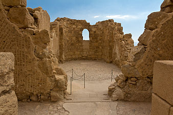
Many of the ancient buildings have been restored from their remains, as have the wall paintings of Herod's two main palaces, and the Roman-style bathhouses that he built. The synagogue, storehouses, and houses of the Jewish rebels have also been identified and restored.
Water cisterns two-thirds of the way up the cliff drain the nearby wadis by an elaborate system of channels, which explains how the rebels managed to conserve enough water for such a long time.
The Roman attack ramp still stands on the western side and can be climbed on foot. The meter-high circumvallation wall that the Romans built around Masada can be seen, together with eight Roman siege camps just outside this wall. The Roman siege installations as a whole, especially the attack ramp, are the best preserved of their kind, and the reason for declaring Masada a UNESCO World Heritage site.
Due to the great interest shown by the public, Yadin published in 1966 a book for the general public, "מצדה" ("Masada").
Masada was declared a UNESCO World Heritage Site in 2001.
In 2007, the Masada Museum in Memory of Yigael Yadin opened at the site, in which archeological findings are displayed in a theatrical setting. Many of the artifacts exhibited were unearthed by Yadin and his archaeological team from the Hebrew University of Jerusalem during the 1960s.[42][43]
The archaeological site is situated in the Masada National Park, and the park requires an entrance fee (even if by hiking). There are two hiking paths, both very steep:
Hikers frequently start an hour before sunrise, when the park opens, to avoid the mid-day heat, which can exceed 43 °C (109 °F) in the summer. In fact, the hiking paths are often closed during the day in the summer because of the heat. Visitors are encouraged to bring drinking water for the hike up, as water is available only at the top.
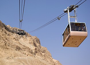
Alternatively, for a higher fee, visitors can take a cable car (the Masada cableway, opens at 8 am) to the top of the mesa.
A visitors' center and the museum are at the base of the cable car.
A light-and-sound show is presented on some summer nights on the western side of the mountain (access by car from the Arad road or by foot, down the mountain via the Roman Ramp path).[44]
In May 2015, 20-year old American tourist Briana McHam fell 25 feet on Masada's Snake Path, after she became separated from her Florida State University tour group and went off the marked trail. Following an hour and a half search, Magen David Adom personnel found her unresponsive and suffering from dehydration. After failed attempts to resuscitate, she was declared dead at the scene.[45]
Legacy[edit]
World War II[edit]
The Masada story was the inspiration for the "Masada plan" devised by the British during the Mandate era. The plan was to man defensive positions on Mount Carmel with Palmach fighters, to stop Erwin Rommel's expected drive through the region in 1942. The plan was abandoned following Rommel's defeat at El Alamein.[51]

![Stepped pool interpreted by Yadin as a Herodian swimming pool, possibly used as a public ritual immersion bath (mikveh) by the rebels (#17 on plan)[49][50]](http://upload.wikimedia.org/wikipedia/commons/thumb/1/18/Masada_mikve.JPG/303px-Masada_mikve.JPG)


