Adriatic Sea
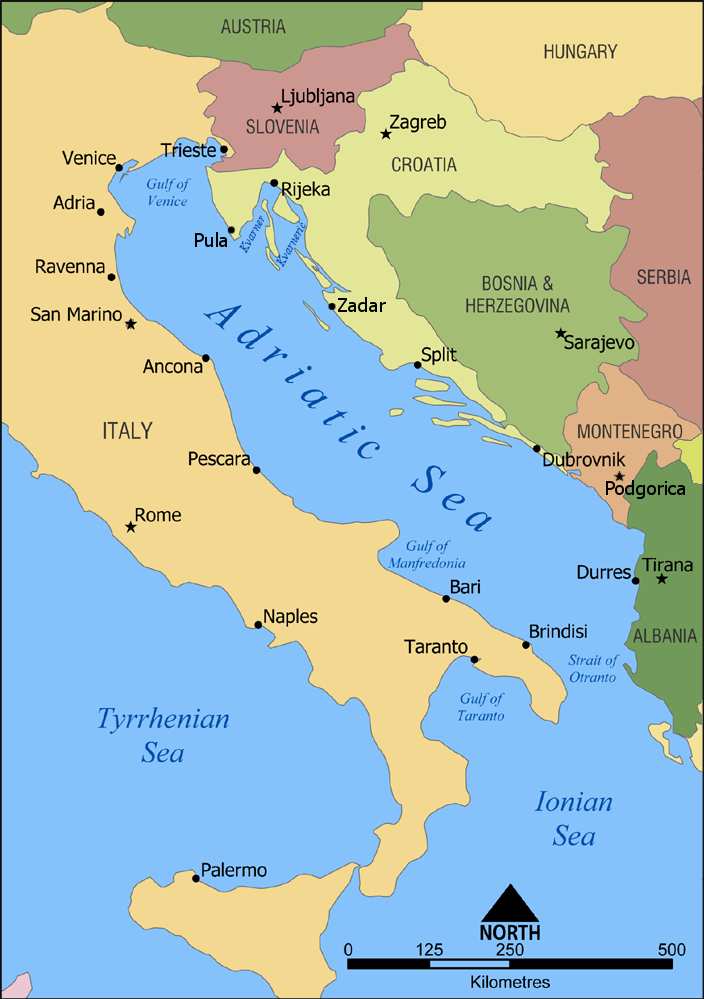
The Adriatic Sea (/ˌeɪdriˈætɪk/) is a body of water separating the Italian Peninsula from the Balkan Peninsula. The Adriatic is the northernmost arm of the Mediterranean Sea, extending from the Strait of Otranto (where it connects to the Ionian Sea) to the northwest and the Po Valley. The countries with coasts on the Adriatic are Albania, Bosnia and Herzegovina, Croatia, Italy, Montenegro, and Slovenia.
"Adriatic" redirects here. For other uses, see Adriatic (disambiguation).Adriatic Sea
From the ancient city of Adria
235,000 km2 (91,000 sq mi)
Bordering: Italy, Albania, Croatia, Montenegro, Slovenia, and Bosnia and Herzegovina
Not bordering: Greece, Serbia, North Macedonia, Kosovo, Austria, Switzerland and France (drainage basins for inflow rivers)[1]
800 km (500 mi)
200 km (120 mi)
138,600 km2 (53,500 sq mi)
252.5 m (828 ft)
1,233 m (4,045 ft)
35,000 km3 (2.8×10¹⁰ acre⋅ft)
3.4±0.4 years
38–39 PSU
3,739.1 km (2,323.4 mi)
28 °C (82 °F)
9 °C (48 °F)
The Adriatic contains more than 1,300 islands, mostly located along the Croatian part of its eastern coast. It is divided into three basins, the northern being the shallowest and the southern being the deepest, with a maximum depth of 1,233 metres (4,045 ft). The Otranto Sill, an underwater ridge, is located at the border between the Adriatic and Ionian Seas. The prevailing currents flow counterclockwise from the Strait of Otranto, along the eastern coast and back to the strait along the western (Italian) coast. Tidal movements in the Adriatic are slight, although larger amplitudes are known to occur occasionally. The Adriatic's salinity is lower than the Mediterranean's because the Adriatic collects a third of the fresh water flowing into the Mediterranean, acting as a dilution basin. The surface water temperatures generally range from 30 °C (86 °F) in summer to 12 °C (54 °F) in winter, significantly moderating the Adriatic Basin's climate.
The Adriatic Sea sits on the Apulian or Adriatic Microplate, which separated from the African Plate in the Mesozoic era. The plate's movement contributed to the formation of the surrounding mountain chains and Apennine tectonic uplift after its collision with the Eurasian plate. In the Late Oligocene, the Italian Peninsula first formed, separating the Adriatic Basin from the rest of the Mediterranean. All types of sediment are found in the Adriatic, with the bulk of the material transported by the Po and other rivers on the western coast. The western coast is alluvial or terraced, while the eastern coast is highly indented with pronounced karstification. There are dozens of marine protected areas in the Adriatic, designed to protect the sea's karst habitats and biodiversity. The sea is abundant in flora and fauna—more than 7,000 species are identified as native to the Adriatic, many of them endemic, rare and threatened ones.
The Adriatic's shores are populated by more than 3.5 million people; the largest cities are Bari, Venice, Trieste and Split. The earliest settlements on the Adriatic shores were Etruscan, Illyrian, and Greek. By the 2nd century BC, the region was under Rome's control. In the Middle Ages, the Adriatic shores and the sea itself were controlled, to a varying extent, by a series of states—most notably the Byzantine Empire, the Croatian Kingdom, the Republic of Venice, the Habsburg monarchy and the Ottoman Empire. The Napoleonic Wars resulted in the First French Empire gaining coastal control and the British effort to counter the French in the area, ultimately securing most of the eastern Adriatic shore and the Po Valley for Austria. Following Italian unification, the Kingdom of Italy started an eastward expansion that lasted until the 20th century. Following World War I and the collapse of Austria-Hungary and the Ottoman Empire, the entire eastern coast's control passed to Yugoslavia and Albania, except for Trieste and surrounding area which remained under Italian control. The former disintegrated during the 1990s, resulting in four new states on the Adriatic coast. Italy and Yugoslavia agreed on their maritime boundaries by 1975 and this boundary is recognised by Yugoslavia's successor states, but the maritime boundaries between Slovenia, Croatia, Bosnia and Herzegovina, and Montenegro are still disputed. Italy and Albania agreed on their maritime boundary in 1992.
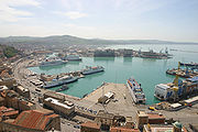
Fisheries and tourism are significant sources of income all along the Adriatic coast. Adriatic Croatia's tourism industry has grown faster economically than the rest of the Adriatic Basin's. Maritime transport is also a significant branch of the area's economy—there are 19 seaports in the Adriatic that each handle more than a million tonnes of cargo per year. The largest Adriatic seaport by annual cargo turnover is the Port of Trieste, while the Port of Split is the largest Adriatic seaport by passengers served per year.
Name[edit]
The origins of the name Adriatic are linked to the Illyrian settlement of Adria, which probably derives its name from Illyrian adur 'water, sea'.[2] In classical antiquity, the sea was known as Mare Adriaticum (Mare Hadriaticum, also sometimes simplified to Adria) or, less frequently, as Mare Superum '[the] upper sea'.[3] The two terms were not synonymous, however. Mare Adriaticum generally corresponds to the Adriatic Sea's extent, spanning from the Gulf of Venice to the Strait of Otranto. That boundary became more consistently defined by Roman authors—early Greek sources place the boundary between the Adriatic and Ionian seas at various places ranging from adjacent to the Gulf of Venice to the southern tip of the Peloponnese, eastern shores of Sicily and western shores of Crete.[4] Mare Superum on the other hand normally encompassed both the modern Adriatic Sea and the sea off the Apennine peninsula's southern coast, as far as the Strait of Sicily.[5] Another name used in the period was Mare Dalmaticum, applied to waters off the coast of Dalmatia or Illyricum.[6] During the early modern period, the entire sea was also known as the Gulf of Venice (Italian: golfo di Venezia),[7] although that name is now informally applied only to the northern area of the sea, from Maestra Point in the Po Delta to Cape Kamenjak on the Istrian Peninsula.
The names for the sea in the languages of the surrounding countries include Albanian: Deti Adriatik; Emilian: Mèr Adriatic; Friulian: Mâr Adriatic; Greek: Αδριατική θάλασσα, romanized: Adriatikí thálassa; Istro Romanian: Marea Adriatică; Italian: Mare Adriatico; Serbo-Croatian: Jadransko more, Јадранско море; Slovene: Jadransko morje; Venetian: Mar Adriàtico. In Serbo-Croatian and Slovene, the sea is often referred to as simply Jadran.
![The Barcolana regatta in Trieste, Italy, was named "the greatest sailing race" by the Guinness World Record for its 2,689 boats and over 16,000 sailors on the starting line.[263]](http://upload.wikimedia.org/wikipedia/commons/thumb/c/cc/Triestebarcolana.jpg/233px-Triestebarcolana.jpg)
